Featured

Diberdayakan oleh Blogger.

0 Lake Toba, Northern Sumatra

     Lake Toba (Indonesian: Danau Toba) is a lake and supervolcano. The lake is 100 kilometres long and 30 kilometres wide, and 505 metres (1,666 ft) at its deepest point. Located in the middle of the northern part of the Indonesian island of Sumatra with a surface elevation of about 900 metres (2,953 ft), the lake stretches from 2.88°N 98.52°E to 2.35°N 99.1°E. It is the largest lake in Indonesia and the largest volcanic lake in the world.
Lake Toba is the site of a supervolcanic eruption that occurred 69,000-77,000 years ago, a massive climate-changing event. The eruption is believed to have had a VEI intensity of 8. It is believed to be the largest explosive eruption anywhere on Earth in the last 25 million years. According to the Toba catastrophe theory to which some anthropologists and archeologists subscribe, it had global consequences, killing most humans then alive and creating a population bottleneck in Central Eastern Africa and India that affected the genetic inheritance of all humans today. This theory however, has been largely debated as there is no evidence for any other animal decline or extinction, even in environmentally sensitive species. However, it has been accepted that the eruption of Toba led to a volcanic winter with a worldwide decline in temperatures between 3-5 degrees C, and up to 15 degrees C in higher latitudes.

Geology

     The Toba caldera complex in Northern Sumatra, Indonesia consists of four overlapping volcanic craters that adjoin the Sumatran "volcanic front". The youngest and fourth caldera is the world's largest Quaternary caldera (100 km (62 mi) by 30 km (19 mi)) and intersects the three older calderas. An estimate of 2,800 km3 (670 cu mi) of dense-rock equivalent pyroclastic material, known the Youngest Toba tuff, was blasted from the youngest caldera during one of the largest single explosive volcanic eruptions in geologic history. Following the "Youngest Toba tuff eruption", a typical resurgent dome formed within the new caldera, joining two half-domes separated by a longitudinal graben.
There are at least four cones, four stratovolcanoes and three craters visible in the lake. The Tandukbenua cone on the NW edge of the caldera is relatively lacking in vegetation, suggesting a young age of only several hundred years. Also, the Pusubukit volcano on the south edge of the caldera is solfatarically active.


Read more

0 Borobudur Temple, Cenral Java

   Borobudur, Barabudur, is a 9 Century mahayana buddist monument near magelang, Central Java, Indonesia. The monument comprises six square platforms topped by three circular platforms, and is decorated with 2,672 relief panels and 504 buddha statues. A main dome, located at the center of the top platform, is surrounded by 72 Buddha statues seated inside perforated stupa.The monument is both a sharie to the Lord buddha and a place for Buddhist pilgrimage. The journey for pilgrims begins at the base of the monument and follows a path circumambulating the monument while ascending to the top through the three levels of buddist cosmology , namely kamadhatu  (the world of desire), rapadhatu (the world of forms) and arupadhatu  (the world of formlessness). During the journey the monument guides the pilgrims through a system of stairways and corridors with 1,460 narrative relief panels on the wall and the balustrades.
Evidence suggests Borobudur was abandoned following the 14th-century decline of Buddhist and Hindu kingdoms in Java, and the Javanese conversion to Islam. Worldwide knowledge of its existence was sparked in 1814 by Sir Thomas Stamford Raffles, then the British ruler of Java, who was advised of its location by native Indonesians. Borobudur has since been preserved through several restorations. The largest restoration project was undertaken between 1975 and 1982 by the Indonesian government and UNESCO, following which the monument was listed as a UNESCO World Heritage Site. Borobudur is still used for pilgrimage; once a year Buddhists in Indonesia celebrate Vesak at the monument, and Borobudur is Indonesia's single most visited tourist attraction.

Location

     Approximately 40 kilometers (25 mi) northwest of Yogyakarta, Borobudur is located in an elevated area between two twin volcanoes, Sundoro-Sumbing and Merbabu-Merapi, and two rivers, the Progo and the Elo. According to local myth, the area known as Kedu Plain is a Javanese 'sacred' place and has been dubbed 'the garden of Java' due to its high agricultural fertility.[Besides Borobudur, there are other Buddhist and Hindu temples in the area, including the Prambanan temples compound. During the restoration in the early 20th century, it was discovered that three Buddhist temples in the region, Borobudur, Pawon andMendut, are lined in one straight line position. It might be accidental, but the temples' alignment is in conjunction with a nativefolk tale that a long time ago, there was a brick-paved road from Borobudur to Mendut with walls on both sides. The three temples (Borobudur–Pawon–Mendut) have similar architecture and ornamentation derived from the same time period, which suggests that ritual relationship between the three temples, in order to have formed a sacred unity, must have existed, although exact ritual process is yet unknown.
Unlike other temples, which were built on a flat surface, Borobudur was built on a bedrock hill, 265 m (869 ft) above sea level and 15 m (49 ft) above the floor of the dried-out paleolake. The lake's existence was the subject of intense discussion among archaeologists in the 20th century; Borobudur was thought to have been built on a lake shore or even floated on a lake. In 1931, a Dutch artist and a scholar of Hindu and Buddhist architecture, W.O.J. Nieuwenkamp, developed a theory that Kedu Plain was once a lake and Borobudur initially represented a lotus flower floating on the lake. Lotus flowers are found in almost every Buddhist work of art, often serving as a throne for buddhas and base for stupas. The architecture of Borobudur itself suggests a lotus depiction, in which Buddha postures in Borobudur symbolize the Lotus Sutra, mostly found in many Mahayana Buddhism (a school of Buddhism widely spread in the east Asia region) texts. Three circular platforms on the top are also thought to represent a lotus leaf. Nieuwenkamp's theory, however, was contested by many archaeologists because the natural environment surrounding the monument is a dry land.
Geologists, on the other hand, support Nieuwenkamp's view, pointing out clay sediments found near the site. A study of stratigraphy, sediment and pollen samples conducted in 2000 supports the existence of a paleolake environment near Borobudur, which tends to confirm Nieuwenkamp's theory. The lake area fluctuated with time and the study also proves that Borobudur was near the lake shore c. 13th and 14th centuries. River flows and volcanic activities shape the surrounding landscape, including the lake. One of the most active volcanoes in Indonesia, Mount Merapi, is in the direct vicinity of Borobudur and has been very active since the Pleistocene.


 reference: wikipedia.org
Read more

0 National Monument (Monas), Jakarta

 The National Monument (Indonesian: Monumen Nasional (Monas)) is a 433 ft (132 meter) tower in the center of Merdeka Square, Central Jakarta, The National Monument, or "Monas" as it is popularly called, is one of the monuments built during the Sukarno era of fierce nationalism. The top of the National Monument (Monas) is Freedom Square. It stands for the people's determination to achieve freedom and the crowning of their efforts in the Proclamation of Independence in August 1945. The 137-meter tall marble obelisk is topped with a flame coated with 35 kg of gold. The base houses a historical museum and a hall for meditations. The monument is open to the public and upon request the lift can carry visitors to the top, which offers a bird's eye view on the city and the sea.

Go early to beat the crowds and the haze. It is easy for the less physically able as lifts take visitors to the top. The diorama exhibition in the basement gives such a distorted view of Indonesian history - thanks to the dictator Suharto wanting to brainwash the nation - it's amusing. This imposing obelisk is Jakarta's most famous landmark. Construction started in 1961 under President Soekarno but was not completed until 1975, under President Soeharto. The monument houses a couple of museums. The Freedom Hall depicts Indonesia's struggle for independence through a series of dioramas, whereas the Hall of Contemplation displays the original Declaration of Independence document and a recording of the speech. An elevator takes one to the observation platform, which commands a bird's-eye view of the cityscape.


more photos :
Read more

0 Derawan Island, East Kalimantan

     Welcome to the beautiful tropical islands in the area of Borneo, Derawan Island. An island with a colorful sea of blue and green shades are stunning, soft sand, palm trees line the coast, with a small forest in the middle of the island which is the habitat of various species of plants and animals and the natural beauty of the enchanting underwater . No wonder the island can be ranked as a top three place world-class diving destination and make this island a dream island for divers. Every month, at least 75 foreign tourists and local tourists hundred visiting Derawan Island. They claim love the charm of the island.

      According to the tourists, the atmosphere of the sea Derawan island very different from other regions. Not to mention the beauty beneath the sea Derawan Island. No wonder, many international-class divers visiting the island for trying out the natural beauty of the underwater Derawan Island. There are also tourists who are interested in looking for turtle eggs because so many turtles on the island. Unfortunately, the manager admitted Derawan difficulty island developing this island because no local government support. As a result, many obstacles that can not be overcome. In the end, they expect the government to open regular shipping for the smooth flow of transport.

       In Derawan Islands there are some coastal ecosystems and small island which is very important that coral reefs, sea grass and mangrove forest (mangroves). In addition many protected species in the Derawan Islands like the green turtle, hawksbill turtle, whales, dolphins, clam, coconut crab, mermaid, fish, barracuda and a few other species. There are many other dive sites in the Derawan area, including Barracuda Point, The Wall, and Blue Light in Kakaban Cave, Big Fish Country, Paradise Reef, and the Light House on the Island Maratua, and other islands of Derawan and Sangalaki. If you want to try it, you'll need at least two weeks! How? It’s too beautiful to be miss out.

more photos:


Read more

0 Komodo Island, Sumbawa Flores

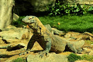
     Komodo National Park is located in the center of the Indonesian archipelago, between the islands of Sumbawa and Flores. Established in 1980. Komodo Island is known as a habitat for native animals dragons. This island is also the Komodo National Park which is managed by the Central Government. Komodo Island in the eastern island of Sumbawa, which are separated by the Sape Strait.Administratively, this island including the District of Komodo, West Manggarai regency,East Nusa Tenggara Province, Indonesia. Komodo Island is the most western tip of Nusa Tenggara Timur province, bordering the province of West Nusa Tenggara.

        On the island of Komodo dragons animals live and breed well. Until August 2009, onthis island there are about 1,300 dragons tail. Coupled with other islands, such as Islandand Rinca and Gili Motang, their numbers totaled about 2500 tails. There are alsoapproximately 100 individuals dragons in Wae Wuul Nature Reserve on the mainlandisland of Flores, but not including the Komodo National Park.Besides Komodo, the island is also store a variety of exotic flora wood by local people Sepang which is used as a medicine and dye clothes, this nitak tree or sterculiaoblongata in the believe is useful as medicines and seeds are tasty and delicious likepeas. 

History: 

        In 1910 the Dutch named the island in the southern province of East Nusa Tenggara is the nickname of Komodo Island. This story begins with Lieutenant Steyn van HensBroek who tries to prove statements about the presence of Dutch troops large animal resembling a dragon on the island. Steyn then killed a dragon and bring documentation to the Museum and Botanical Garden in Bogor to be investigated. In 2009, the park has been named a finalist in the: New Seven Wonders of Nature” newly pubhlished in 2010 by online voting at www.N7W.com


 referensi : komodonationalpark.org
Read more

0 Islamic Center Samarinda, East Kalimantan


    Samarinda Islamic Center Mosque is located in Teluk Lerong Ulu, Samarinda, East Kalimantan, Indonesia, which is the grandest and the second largest mosque in Southeast Asia after Istiqlal Mosque. In the foreground of the banks of the Mahakam River, this mosque has a tower and a large dome that stands upright.

       This mosque has a main building area of ​​43,500 square meters. To support the building area is 7115 square meters and floor area of ​​10,235 square meters basement. While the ground floor of the mosque area of ​​10,270 square meters and the main floor area of ​​8185 square meters. While mezanin floor area (balcony) is 5290 square meters. This location was formerly a land area of ​​the former sawmill property Inhutani, which then donated to the Provincial Government of East Kalimantan. The building of this mosque has a tower which was 7 99-meter-high main tower meaningful Asmaul Husna or the names of God that the number 99. The main tower consists of building 15 floors each floor as high as the average 6 meters. Meanwhile, steps from ground floor to the main floor of the mosque in number as much as 33 steps.This amount is deliberately equated to one-third the number of beads.

         In addition to the main tower, this building also has 6 towers on the side of the mosque.Each 4 in every corner of the mosque as high as 70 meters and 2 towers at the gate as high as 57 meters. Six of the tower is also significant as 6 pillars of faith.

      Islamic Center of Development is expected to also evoke the spirit of togetherness in an effort to face the global era, in addition to a public demand for Samarinda have an adequate place of worship facilities.

more photos :


the 99 meters high main tower


main gate


Islamic center
Read more

Delete this element to display blogger navbar

 
© Visit Indonesia | Design By BlogTamplate in collaboration with Concert Tickets, and Menopause symptoms
Powered by Blogger